Home
» Today
»
El Niño 2026: What California Could See This Winter—and What We Still Don’t Know
El Niño 2026: What California Could See This Winter—and What We Still Don’t Know
Updated September 22, 2026. El Niño is no longer just a possibility for the coming California winter. NOAA’s Climate Prediction Center (CPC) says El Niño conditions are present and strengthening, with a greater than 90% chance of a very strong event during Northern Hemisphere fall and winter 2026–27. In its September 10 update, CPC also estimated a 75% chance that the October–December 2026 three-month Relative Oceanic Niño Index, or RONI, would exceed +2.5°C—a level that would be historically exceptional in the modern record.
That is the part that is verified. What is not verified is a specific rainfall total for Los Angeles, San Francisco, Sacramento, San Diego, the Sierra Nevada, or California as a whole. El Niño changes the odds of certain large-scale weather patterns; it does not lock in a particular storm sequence months in advance.
The practical takeaway is to treat El Niño as a useful seasonal signal, not a promise. California residents, businesses, travelers, and water managers can prepare for a higher likelihood of wet conditions in parts of the state while still relying on shorter-range forecasts for actual storm decisions.
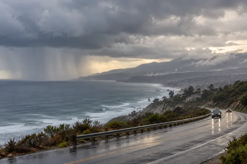
Rain bands approach a wet coastal highway beside the Pacific. El Niño can raise the odds of a storm track favoring California, but individual storms still require short-range forecasts.
What NOAA has actually confirmed about El Niño 2026
NOAA’s September 2026 ENSO Diagnostic Discussion lists the alert status as an El Niño Advisory. CPC reported that the coupled tropical ocean and atmosphere were showing a strengthening El Niño, with the Niño-3.4 index at +1.8°C in August and other eastern Pacific Niño indices even warmer.
CPC’s official outlook is unusually confident about the event itself. Its September 2026 RONI outlook projects El Niño through the heart of the 2026–27 winter. However, the strength of the ocean signal and the weather experienced in one California city are not the same forecast problem.
Action: Use the ENSO advisory to guide seasonal preparation. For a decision tied to a date—driving through a mountain pass, protecting a construction site, clearing a drainage system, or scheduling travel—switch to National Weather Service forecasts and warnings as the date approaches.
Misconception: “A very strong El Niño guarantees a very wet California winter”
It does not. A stronger El Niño generally makes certain characteristic weather patterns more likely, but NOAA explicitly cautions that even a very strong event does not guarantee those impacts in any given location.
There is a real historical relationship behind the wet-winter expectation. Research archived by NOAA that examined California precipitation from 1901–2010 found that El Niño’s influence tends to be stronger in late winter and stronger in Southern California than in Northern California. The same study found that most moderate-to-strong El Niño events placed Southern California in the wettest third of late-winter outcomes. That is useful evidence, but it is still a probability distribution, not a deterministic forecast.
The current seasonal forecast also supports a wetter tilt. CPC’s September 17 long-lead outlook discussion favors above-normal precipitation across the southern half of California for October–December 2026. From late fall into early spring, CPC says the odds of above-normal precipitation increase across California, reaching roughly 50–60% near parts of the coast in some seasonal windows.
Those percentages do not mean that 50–60% more rain will fall. They mean the probability of the season finishing in the “above-normal” precipitation category is higher than usual.
Action: If you are planning around winter rainfall, use CPC’s seasonal outlook to decide whether extra preparation is warranted, but do not use it to estimate a roof leak date, a road closure date, or a reservoir inflow total.
Misconception: “El Niño means the same weather everywhere in California”
California is too large and geographically varied for that. Northern California, the Central Coast, Southern California, inland valleys, desert areas, and the Sierra Nevada can respond differently to the same broad Pacific pattern.
The historical wet signal associated with El Niño is generally clearer in Southern California than in the north. The 2026 CPC outlook also varies by season: the early fall-to-winter signal is more pronounced across the southern half of the state, while wetter-than-normal odds become broader later in the cool season.
Even within one region, elevation matters. A storm can produce heavy rain at lower elevations while adding snow at higher elevations. ENSO by itself does not specify the freezing level of each storm, so it cannot tell Californians in September exactly how much of winter precipitation will become Sierra snowpack rather than rain.
Action: Check the forecast for your region rather than applying a statewide headline to a local decision. California’s California Water Watch is useful for tracking precipitation, reservoirs, streamflow, soil moisture, and snow conditions as the water year develops.
Why atmospheric rivers still matter more than the label on a single day
A California winter can be shaped disproportionately by a small number of major storms. The California Department of Water Resources notes that about 75% of the state’s annual precipitation falls from November through March, and that a handful of atmospheric rivers—or the absence of them—can determine whether a water year ends wet or dry.
That is one reason an El Niño outlook cannot answer the question “Will it rain a lot this winter?” with certainty. El Niño may shift the Pacific jet stream and storm track in a way that favors more storms across the southern United States and California. But the exact number, strength, landfall location, and spacing of atmospheric rivers remain weather-scale questions.
A season could end wetter than average because of several powerful events separated by long dry periods. Another season could have many modest storms without extreme totals. Seasonal averages alone do not describe the sequence people actually experience.
Action: Treat atmospheric-river forecasts and local flood products as the operational signal. If a strong storm is expected, check National Weather Service watches and warnings, local emergency-management guidance, and road conditions rather than relying on the El Niño label.
What a wetter El Niño pattern could mean for California
Issue
What is reasonably supported now
What is still unknown
Seasonal precipitation
Above-normal precipitation is favored in Southern California in the October–December 2026 outlook, with wetter odds expanding later in winter.
Exact totals for any city, watershed, or month.
Storm track
El Niño typically favors a more southerly Pacific jet and storm track, especially in stronger events.
The exact path and intensity of individual storms.
Flooding and debris flows
A wetter storm pattern can increase opportunities for flooding, and intense rain can raise debris-flow risk in vulnerable terrain.
Which communities will face a damaging event and when.
Sierra snowpack
More precipitation can increase opportunities for mountain snow.
How much falls as snow versus rain, because storm temperature and snow level vary.
Water supply
A wet winter can improve reservoir inflows and water conditions.
Final storage outcomes, which depend on storm timing, runoff, operations, antecedent conditions, and spring melt.
Action: Prepare for the hazards that matter at your location. In flood-prone areas, clear drainage paths and review evacuation routes. In mountain communities, prepare for both heavy snow and rain-on-snow possibilities. In coastal or hillside areas, pay attention to local landslide and debris-flow messaging during intense storms.
Could California still have dry stretches during a strong El Niño?
Yes. A wet seasonal tendency does not require continuous rain. California’s precipitation climatology is already highly concentrated into the cool season and into relatively few storms. Large-scale climate patterns can also be interrupted by shorter-lived circulation features that divert storms away from the state for days or weeks.
This is an important distinction because “wet winter” and “rainy every week” are not synonyms. The season can contain both flood-producing storms and meaningful dry breaks.
Action: Avoid making water-use, agricultural, travel, or construction decisions from a single seasonal label. Update plans as the 6–10 day, 8–14 day, monthly, and seasonal outlooks converge or diverge.
What we still do not know in late September 2026
Several questions cannot be answered responsibly this far ahead. We do not know the total 2026–27 rainfall for California, whether Los Angeles or San Diego will exceed a particular seasonal record, how many major atmospheric rivers will make landfall, or whether any specific watershed will flood.
We also do not yet know the final balance between rain and snow in the Sierra Nevada. CPC’s fall and winter temperature outlooks favor above-normal temperatures across much of the West in several periods, but the precipitation type during a particular storm will depend on that storm’s thermal profile and snow level.
Finally, a historically strong tropical Pacific signal does not automatically mean historically strong impacts in California. The atmosphere is influenced by multiple patterns at once, and those patterns can reinforce or weaken the typical El Niño response.
Action: Recheck the outlook monthly. CPC’s ENSO discussion is normally updated on the second Thursday of each month, and its seasonal outlooks are refreshed monthly as new ocean observations and model runs become available.
How to judge whether the forecast is becoming more useful
A good forecast should become more specific as the event gets closer. In September, the most useful information is the broad seasonal tilt: a very strong El Niño is likely, and wetter-than-normal conditions are favored for parts of California. By late fall and winter, useful evidence should shift toward actual storm tracks, atmospheric-river forecasts, snow levels, soil saturation, reservoir conditions, and local flood thresholds.
You should change from seasonal planning to event-level action when forecasters begin identifying a specific storm or multi-day period. At that point, a county warning, river forecast, or mountain snowfall forecast is more relevant than the ENSO index.
Action: Use a simple hierarchy: ENSO for seasonal context, CPC outlooks for multiweek-to-seasonal probability, National Weather Service products for specific weather, and local emergency alerts for immediate action.
Bottom line for California
El Niño 2026 is real, strengthening, and—according to NOAA—very likely to be very strong during fall and winter 2026–27. The latest official seasonal outlook increases the odds of above-normal precipitation in Southern California first, with a broader wet signal across California later in the cool season.
What that does not establish is a guaranteed deluge, a statewide rainfall total, or a prediction that every part of California will be wet at the same time. The better interpretation is that the background climate pattern is tilting the odds toward a wetter and potentially more active winter, especially in parts of Southern and coastal California, while the outcomes that matter most—individual atmospheric rivers, floods, snow levels, and local impacts—will only become clear closer to each event.