Home
» Today
»
SS United States Reefing: What Florida’s New Artificial Reef Means for Tourism and Divers — Nov. 11, 2026
SS United States Reefing: What Florida’s New Artificial Reef Means for Tourism and Divers — Nov. 11, 2026
Updated November 11, 2026, at 4:36 p.m. Central Standard Time (CST, UTC−06:00; 10:36 p.m. UTC).
The SS United States has been scuttled off Florida’s Emerald Coast and is beginning a new life as an artificial reef. The 990-foot ocean liner now rests about 22 nautical miles southwest of Destin-Fort Walton Beach, where it is expected to become a draw for offshore dive charters and fishing trips. For visitors, the change is immediate in one respect: the ship is no longer a waterfront attraction to see from shore. For divers, the wreck’s depth and access rules matter more than its headline size.
The reef’s tourism value and ecological effects are still projections. Okaloosa County expects the site to support local businesses and marine habitat, while scientists from the Woods Hole Oceanographic Institution (WHOI) and partner institutions will track how the new ecosystem develops. The county’s dive information puts the seabed at about 180 feet, with the upper deck roughly 55 to 60 feet below the surface; public access and charter details should be checked with official sources before making a trip specifically to dive it.
Highlights
The SS United States was scuttled on November 11, 2026, about 22 nautical miles southwest of Destin-Fort Walton Beach.
The wreck’s upper deck is expected to sit around 55–60 feet deep; the seabed is about 180 feet down.
Local tourism benefits are an expectation, not yet a measured economic result.
WHOI researchers plan multi-year monitoring of water chemistry, microbes, and marine life around the ship.
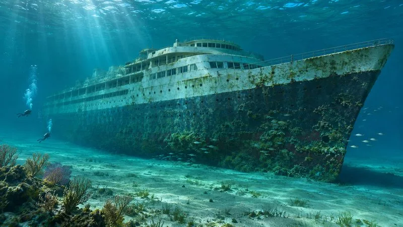
Illustration: a historic ocean liner as an artificial reef in the Gulf. This is an artist-generated scene, not a photograph of the SS United States wreck.
What happened to the SS United States?
WHOI’s November 11 release confirms that the ship was scuttled off Destin-Fort Walton Beach and describes the site as a new artificial reef and research location. Okaloosa County selected a site about 22 nautical miles southwest of the Destin East Pass. That distance puts the attraction offshore, requiring a boat trip rather than a beach visit.
Before deployment, the county says the vessel underwent more than a year of remediation. Its published checklist says all 128 fuel and lubricant tanks were emptied, cleaned, inspected, and certified clean; more than 200 material samples were collected to assess regulated polychlorinated biphenyls (PCBs); and the high-PCB green deck covering, loose exterior paint, wiring, and other materials were removed. The funnels, radar mast, propeller, portholes, and other artifacts were retained for land-based interpretation. These are the county’s reported preparation measures; post-deployment monitoring will add evidence about how the site behaves in the marine environment.
What could the reef mean for Florida Panhandle tourism?
County officials expect the wreck to bring divers, anglers, and visitors to Destin-Fort Walton Beach, with potential spending at dive shops, charter operators, hotels, restaurants, and other tourism businesses. Those are reasonable channels for an impact, but no post-opening visitor counts, bookings, or local revenue figures are available yet. The project’s long-run commercial value will depend on safe access, weather, charter capacity, visitor demand, and the condition of the wreck—not simply on its size or record-setting label.
The attraction is likely to serve a different visitor than the area’s beach tourism. A 22-nautical-mile offshore site is not visible from shore, and a trip to it requires a boat and suitable sea conditions. Non-divers can follow research and deployment updates and visit a planned land-based museum, where the Conservancy and county say artifacts will help tell the liner’s story. That museum would give the project a shore-based option, but it should not be treated as open until organizers announce its schedule.
For travelers, the practical move is to check the county’s deployment and diving pages and contact a local operator before booking. Ask whether trips are running, what certification or experience the operator requires, what equipment is included, and whether the wreck’s final position and access status have been confirmed. Weather, currents, visibility, and boat availability can affect an offshore plan, so keep a flexible itinerary.
What should divers know before visiting the SS United States wreck?
Destin-Fort Walton Beach’s diving page gives an expected depth of about 180 feet to the bottom and 55 to 60 feet to the upper deck. That range makes the wreck potentially accessible to a wider range of certified divers than a site whose entire structure lies near the seabed, but it does not make every deck, compartment, or penetration suitable for every diver. Depth, gas planning, current, visibility, and the operator’s rules should guide the decision. The county says unsafe lower compartments and passages were addressed during preparation; divers should still follow the charter’s briefing and stay within their training and limits.
As of this check, the official information reviewed describes the reef and expected diving depths but does not provide a confirmed, general public opening schedule. Treat the wreck as a new site whose exact resting position and operating procedures may still be under review. Do not assume that an advertised future trip is running until the operator confirms it directly.
How will scientists measure the reef’s environmental effects?
WHOI says researchers will study changes in surrounding water chemistry, microbial activity, and biological communities over multiple years. Within the first month, the team plans to record a baseline of the ship’s condition, nearby chemistry, and early marine life. WHOI’s stated plan includes water samples from 132 locations around the vessel and annual site visits. Researchers say divers may eventually contribute photographs to a citizen-science dataset, though that program is a longer-term goal rather than a current visitor service.
That monitoring matters because an artificial reef is not an instant substitute for a mature natural reef. Marine organisms colonize structures over time, and the balance between habitat gains and environmental effects has to be observed. The county reports extensive cleanup and permitting; the independent scientific work will help document what happens after deployment. Neither the anticipated tourism boost nor the ecological benefits should be presented as already measured outcomes.
It was deployed about 22 nautical miles southwest of the Destin East Pass, off Florida’s Panhandle in the Gulf of Mexico.
How deep is the wreck?
The seabed is about 180 feet deep; the upper deck is expected to be roughly 55–60 feet below the surface.
Can the public dive it now?
The official pages reviewed list expected depths but no confirmed general public opening schedule. Check with Okaloosa County and local dive operators before planning a trip.