Home
» Today
»
NASA Curiosity’s Mars Dawn Image Reveals Wind-Carved Cliffs—Here’s What It Shows
NASA Curiosity’s Mars Dawn Image Reveals Wind-Carved Cliffs—Here’s What It Shows
NASA’s latest Curiosity rover panorama is a study in what early morning light can reveal about Mars. Released on October 6, 2026, the image shows a rugged expanse of Gale Crater’s Mount Sharp, with distant, wind-carved cliffs catching the dawn. The formations are called yardangs, and their geology matters more to the rover’s team than the unusual colors alone.
There are several sensible ways to examine this new Mars dawn image: enjoy the broad landscape, zoom in on the enigmatic cliffs, or compare it with other rover panoramas. Each choice answers a different question, and the processing behind the pictures changes what can be inferred from their colors.
What does Curiosity’s new Mars dawn image actually show?
Curiosity captured the scene on August 11, 2026, at about 8:30 a.m. local Mars time, on mission sol 4,982. A sol is a Martian solar day, slightly longer than an Earth day. The rover’s Mast Camera, or Mastcam, took six individual photographs; those frames were stitched into a panorama after transmission to Earth. The panorama was released in early October, so its publication date should not be mistaken for its acquisition date.
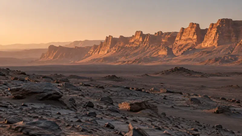
Across the rocky foreground and the distant horizon, the morning illumination emphasizes changes in slope and relief. The prominent faraway crags are yardangs: ridges and cliffs sculpted by wind erosion. NASA describes this release as its most detailed view yet of the distant formations that the science team plans to investigate more closely. The image is not evidence of a new sunrise phenomenon or a recently discovered structure built by life.
Readers looking for the actual spacecraft photograph should use NASA Photojournal entry PIA25629. The page also provides a cropped Figure A that highlights the yardangs, with image credit to NASA/JPL-Caltech/MSSS.
A rocky, windswept landscape under low morning light shows how illumination can pick out ridges, loose stones, and distant cliff faces. For the actual Curiosity observation, consult NASA’s linked PIA25629 panorama.
Why are scientists interested in the yardang layer?
Curiosity has been climbing Mount Sharp since 2014. The roughly 3-mile-tall (5-kilometer-tall) mountain sits inside Gale Crater, and its rock layers preserve part of the environmental record that the rover was sent to investigate. The yardang-bearing unit is unusual because its color and tilted layers do not fit neatly with nearby strata. As Curiosity project scientist Ashwin Vasavada explained in NASA’s October 6 mission report, its origin remains uncertain.
One possibility is that the unit contains material deposited by ancient volcanic activity, including ash. That is a scientific hypothesis, not a confirmed identification from this distant photograph. Another relevant idea is that erosion removed some earlier material before the yardang layer formed, leaving a gap in the succession of rocks that scientists use to reconstruct the planet’s climate history. Photographs can show shape, position, and visible layering, but cannot alone establish mineral chemistry or deposition history.
The rover’s longer-term route is therefore central to interpreting the picture. NASA expects Curiosity to investigate sulfate- and carbonate-bearing layers as it continues uphill and hopes it can reach the base of the yardangs sometime in 2027. Close-range observations and instruments on its robotic arm could help distinguish competing explanations, although the actual route and schedule depend on safe driving and mission operations.
Wide panorama, zoomed crop, or color comparison: which should you choose?
There is no universally best version of a rover scene. Your purpose should determine the image to inspect.
Viewing option
Best for
Trade-off or limitation
Full six-frame panorama
Understanding the broad landscape, foreground, horizon, and relative placement of landforms
Small distant yardangs are less obvious on a narrow screen
NASA’s Figure A crop
Studying the shapes and inclined-looking surfaces of the remote cliffs
Removes surroundings that help establish geographic context
Processed dawn-color image
Seeing the early-morning mood and contrasts that motivated the public release
Colors are affected by lighting and processing; they are not direct mineral identifications
Other NASA panoramas with different color treatment
Understanding how scientific presentation choices change appearance
Different dates, directions, cameras, and processing methods limit direct side-by-side conclusions
Choose the full scene for geographic context
Start with the full panorama if you want to understand where the cliffs lie in relation to the visible landscape. Wide mosaics are useful for tracing broad boundaries and assessing why a distant target has attracted the team’s attention. But a stitched image is not a survey-grade topographic map. It should not be used to calculate exact yardang heights or distances without calibrated supporting data.
Choose the crop to inspect the landforms
If the question is “What exactly is unusual about those faraway cliffs?”, open the zoomed crop in JPL’s original panorama and cropped view. It directs attention to the erosion-carved shapes and visible layering. Remember that enlarging a crop does not create new measured detail: it magnifies information that was already present in the source exposures.
Choose an official image record when accuracy matters
For schoolwork, an explainer, or a social-media post, download from NASA or JPL instead of a repost stripped of context. Include the capture date, release date, rover, camera, and source credit. For geologic claims, distinguish observed features from ideas still being tested. For scientific measurements, seek the underlying mission data and appropriate calibration rather than making estimates from a display image.
Why does part of the scene look blue instead of the familiar Mars red?
The short answer is lighting plus image processing. According to JPL’s PIA25629 description, the team chose not to apply the Mastcam’s usual white balancing to this panorama. White balancing adjusts color appearance in an attempt to compensate for the illumination under which an image was taken. Omitting that routine step helped retain the early-morning look, including the cool tones NASA notes in the foreground.
This does not mean Mars has suddenly changed color, or that the entire surface seen by human eyes would look exactly like the pixels on a particular device. Apparent color is shaped by atmospheric dust, sunlight, the camera response, processing, and your screen. Likewise, the dramatic dawn should not be confused with an image of the solar disk itself: the newsworthy subject is the sunlight falling on the cliffs.
To see why that distinction matters, consider NASA’s separate Curiosity image commemorating the rover’s 5,000th Martian day. That postcard deliberately combines observations from different times of day and adds color to distinguish them. NASA documents the morning and afternoon inputs in NASA’s sol-5,000 postcard record. The new August 11 Mastcam panorama is a different product, with six frames taken during the morning and without the usual white-balancing treatment. It is a mistake to apply the postcard’s color explanation to the new dawn panorama.
How does the image fit Curiosity’s broader mission?
Since landing in Gale Crater in 2012, Curiosity has examined rocks for evidence of how ancient Martian conditions changed and whether past environments could have supported microbial life. Mount Sharp’s sequence of sedimentary and other deposits gives the rover a way to explore that history as it climbs. The newest distant view flags a compelling geological target rather than delivering a final verdict about its origin.
On August 26, 2026, NASA reported a separate milestone: the rover had climbed 1 kilometer in elevation above the crater floor. That ascent underscores how the mission is progressively reaching different layers, though the elevation milestone is not something established by the dawn image itself. NASA describes the related observations in NASA’s elevation milestone update.
Investigating the yardangs in person would offer a scientific advantage over continuing to photograph them from afar. Closer views could resolve textures, relationships among layers, and targets for chemical analysis. The trade-off is that rover travel is slow and must account for terrain, engineering limits, and other science priorities. The expected 2027 arrival is a plan, not a guaranteed appointment.
What can you conclude now—and what remains unknown?
The verified conclusions are narrow but valuable: Curiosity captured a six-image morning panorama on sol 4,982; distant wind-eroded cliffs are visible; and NASA intentionally retained a distinctive dawn color appearance. The formation mechanism of the yardang layer, including a possible volcanic-ash origin, remains unsettled. The image alone neither proves ancient volcanic deposits nor reveals evidence of life.
For a quick visual appreciation, look at the full panorama. For learning about wind erosion, compare it with the magnified yardang crop. For an accurate science explanation, prioritize the NASA Photojournal metadata and JPL’s processing notes over what colors seem to suggest. And for the eventual answer about how this unusual layer formed, the most informative evidence may still be ahead of the rover.