Home
» Technology
»
Designing Resilient Urban Centers: Green Infrastructure for Tomorrow’s Megacities
Designing Resilient Urban Centers: Green Infrastructure for Tomorrow’s Megacities
Green infrastructure has moved from the margins of urban design toward the center of climate-risk planning. Two recent official developments make that shift especially clear. On June 2, 2026, the United Nations Environment Programme launched its 50@50 initiative on extreme heat, bringing more than 50 cities together to strengthen heat preparedness and accelerate practical cooling measures. In 2026, the United Nations Office for Disaster Risk Reduction also published Waves of Change, emphasizing that resilient urban water systems depend on risk data, coordinated governance, sustained investment, community engagement, and approaches that include nature-based solutions.
For people planning, financing, or managing fast-growing cities today, the implication is straightforward: trees, wetlands, green roofs, permeable streets, restored waterways, and other nature-based systems should not be treated as decorative extras. They can function as part of the city’s heat, stormwater, public-health, biodiversity, and public-space infrastructure. They also have limits, so the strongest plans combine green, blue, and conventional engineered systems rather than expecting nature alone to solve every hazard.
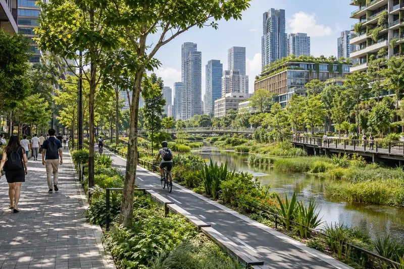
A resilient urban district can combine shade trees, active transportation, planted waterways, public space, and dense development in one connected green-blue network.
Why megacities need a different infrastructure model
The scale of urban growth makes the question urgent. The United Nations Department of Economic and Social Affairs’ World Urbanization Prospects 2025 counted 33 megacities with at least 10 million inhabitants in 2025, up from eight in 1975, and projected 37 by 2050. The same revision found that one in five people worldwide lived in a city of at least one million inhabitants in 2025.
Large urban populations concentrate exposure. A single heat wave can affect millions of residents at once. A storm can overload drainage systems across multiple districts. Paved surfaces and dark roofs store heat, while impervious development accelerates runoff. At the same time, land is expensive and public budgets are constrained. A park that only provides recreation, a drain that only moves water, or a road verge that only separates traffic may be a missed opportunity.
Green infrastructure addresses this by designing land, vegetation, soils, and water to perform several services at once. The IPCC’s assessment of cities and infrastructure notes that green and blue infrastructure can reduce temperature shocks, support sustainable urban water management, and contribute to adaptation. UN-Habitat’s World Cities Report 2024 likewise calls for equitably distributed nature-based solutions as part of urban climate action.
What counts as green infrastructure?
Green infrastructure is best understood as a connected system rather than a list of isolated projects. It may include urban forests, street trees, parks, green roofs and walls, rain gardens, bioswales, vegetated medians, restored floodplains, wetlands, stream corridors, permeable public spaces, and soils designed to store and infiltrate water. “Blue infrastructure” refers to water-related features such as rivers, canals, ponds, wetlands, and retention areas. In practice, the most resilient designs are often described as green-blue infrastructure because vegetation and water are planned together.
UNEP’s urban ecosystem-based adaptation guidance highlights trees, vegetation, water bodies, rooftop gardens, and green surfaces as tools that can reduce urban heat while improving comfort and supporting other urban benefits. The key is to match each intervention to the hazard, climate, soils, urban form, and maintenance capacity of the place.
Design the network around risks, not around leftover space
A common failure is to add greenery after the street grid, buildings, drainage, and utility corridors have already been fixed. Resilient planning reverses that sequence. It starts by mapping how heat, water, ecology, movement, and vulnerability behave across the city, then reserves space for systems that need continuity.
1. Start with the watershed and the heat map
Flood resilience should be planned from the catchment scale down to individual blocks. Planners need to know where runoff is generated, where it can safely be stored, where drainage bottlenecks occur, and which downstream neighborhoods face the greatest consequences when systems fail. Heat planning needs similar spatial intelligence: tree canopy, shade, surface materials, building density, nighttime temperatures, power reliability, and the location of people who are most vulnerable to extreme heat.
This allows the city to place interventions where they change system performance rather than where land happens to be available. A wetland upstream of a flood-prone district may be more valuable than a small ornamental park elsewhere. A continuous shaded walking route to schools, transit, clinics, and markets may improve daily heat protection more than scattered tree planting with no pedestrian connection.
2. Use layers of protection
No single green measure should carry the entire resilience strategy. A robust system combines multiple layers: green roofs and rainwater capture at buildings; tree pits, rain gardens, and permeable areas along streets; parks and detention spaces at the neighborhood scale; and wetlands, rivers, floodplains, forests, or coastal ecosystems at the larger landscape scale. Conventional drainage, pumping, flood barriers, cooling centers, emergency response, and building standards remain important where hazards exceed what nature-based systems can safely handle.
3. Protect existing ecosystems before trying to rebuild them
Mature urban trees, functioning wetlands, floodplains, mangroves, and intact waterways often provide services that are difficult or slow to recreate after removal. Protecting them can be more reliable than clearing them and later attempting to build engineered substitutes. Restoration still matters, but it should not become an excuse for avoidable ecosystem loss.
Choose interventions by the service they must deliver
Urban challenge
Useful green-blue infrastructure
What to measure
Extreme heat
Street trees, urban forests, shaded parks, green roofs, planted courtyards, water-sensitive public spaces
Shade coverage, canopy survival, surface and air temperatures, pedestrian thermal comfort, access for heat-vulnerable groups
Floodplain restoration, wetlands, mangroves where ecologically appropriate, setback zones, absorbent open space
Protected flood storage, water levels, erosion, habitat condition, people and assets exposed during design events
Public-health and mobility gaps
Connected parks, tree-lined walking and cycling routes, green schoolyards, accessible waterfronts
Walkable access, use by age and income groups, shade on key routes, safety, maintenance quality
Biodiversity fragmentation
Habitat corridors, native planting, river restoration, connected parks and wetlands
Habitat connectivity, species indicators, vegetation diversity, ecological condition over time
The table is deliberately performance-based. A project should not be considered successful simply because a certain number of trees were planted or a green roof was installed. The relevant question is whether the intervention continues to provide the intended service after several hot seasons, heavy storms, maintenance cycles, and periods of drought.
Make urban nature equitable, usable, and healthy
Green infrastructure can improve daily life, but distribution matters. A citywide increase in canopy can still leave low-income districts, informal settlements, schools, transit stops, and outdoor workers exposed to heat. UN-Habitat emphasizes that resilience must address the unequal conditions that shape vulnerability, not only the physical hazard itself.
Health is another reason to focus on access rather than acreage alone. The World Health Organization’s 2025 technical brief Green spaces: sectoral solutions for air pollution and health summarizes evidence linking green-space exposure with mental, physical, behavioral, and social health benefits. That does not mean every green space produces the same outcome. Location, safety, accessibility, vegetation type, maintenance, traffic exposure, and whether people can comfortably use the space all influence its value.
Design teams should therefore ask who benefits, who maintains the space, who may be displaced by rising land values, and who bears any downsides. Heat-adaptation investment that makes a neighborhood more attractive but contributes to displacement can undermine its social-resilience goal. Anti-displacement measures, affordable housing policy, tenant protections, and community participation may need to sit alongside the landscape project.
Plan for maintenance before construction
Green infrastructure is living infrastructure. Trees need establishment watering and pruning. Bioswales need sediment and trash removal. Inlets can clog. Wetlands can be damaged by polluted flows. Green roofs require inspection, drainage maintenance, and vegetation management. Poorly maintained systems may lose capacity or create nuisance conditions.
That means lifecycle funding should be part of the capital decision, not a later operational problem. Procurement should define who is responsible for maintenance, what performance will be monitored, how failures will be corrected, and how long the city expects the asset to function. Species selection must fit local heat, rainfall, water availability, salinity, wind, soil volume, and future climate conditions rather than simply follow an aesthetic preference.
Know the limits of green infrastructure
Nature-based solutions are not universally interchangeable with conventional infrastructure. In arid cities, large areas of water-demanding vegetation may conflict with water-security goals. In dense districts, underground utilities and limited soil volume can constrain tree growth. Green roofs add structural and waterproofing requirements. Wetlands and floodable parks need sufficient land and safe overflow routes. Coastal vegetation can reduce some wave and erosion impacts but cannot eliminate the need for evacuation planning or engineered protection where exposure is extreme.
There is also uncertainty. Climate conditions are changing, and a design based only on historical rainfall or heat may underperform in the future. The safer approach is to use scenarios, redundancy, and adaptive management: monitor the system, compare results with service targets, and be ready to expand storage, add shade, change planting, or strengthen conventional infrastructure when evidence shows that risk is rising faster than expected.
A practical framework for tomorrow’s megacity
City leaders do not need to wait for a perfect master plan before acting, but isolated pilot projects should connect to a larger system. A practical sequence is to establish a citywide baseline, define measurable service targets, protect high-value existing ecosystems, identify priority corridors and catchments, assemble a portfolio of green-blue and engineered measures, fund maintenance, and monitor results transparently.
Useful citywide indicators include tree-canopy survival rather than planting totals; shaded access to essential destinations; runoff captured or delayed during storms; flood depth and duration in vulnerable districts; restoration of riparian or wetland function; public access to green space; biodiversity condition; and the distribution of benefits across neighborhoods. There is no single universal target for all climates and cities, so thresholds should be justified using local hazard data, public-health needs, ecological conditions, and engineering requirements.
The World Bank’s 2025 overview of nature-based solutions for disaster and climate resilience shows that these approaches are already being used in urban resilience, coastal resilience, and landscape restoration projects. The broader lesson is not that every city should copy the same park or wetland design. It is that nature can be financed and managed as functional infrastructure when projects are tied to clear risk-reduction objectives and long-term operations.
What resilient urban centers should look like
Tomorrow’s resilient megacity will not be a city covered in greenery for appearance’s sake. It will be a city where natural systems are deliberately connected to transportation, housing, drainage, health, energy, and public-space decisions. Streets will provide shade and manage runoff. Parks will offer recreation while storing stormwater. Restored waterways will support habitat while creating safe flood capacity. Dense development will be paired with accessible green space instead of forcing residents to choose between urban efficiency and environmental quality.
The most durable principle is also the simplest: design green infrastructure as a service network. Protect what already works, connect interventions across scales, measure performance, maintain the assets, and combine nature-based measures with engineered systems where needed. That approach will not remove every climate risk, but it gives rapidly growing urban centers a more flexible and multifunctional foundation for living with heat, water, and ecological pressure over the decades ahead.