Home
» Technology
»
Last-Mile Sky Delivery: How Low-Altitude Networks Are Scaling Global E-Commerce
Last-Mile Sky Delivery: How Low-Altitude Networks Are Scaling Global E-Commerce
Drone delivery is moving beyond isolated pilot projects, but the biggest change is not simply better aircraft. It is the emergence of low-altitude delivery networks: launch sites, charging and maintenance, digital ordering, flight authorization, traffic-awareness services, detect-and-avoid systems, customer handoff, and fallback logistics working as one system.
The important qualifier is that this network is not yet one standardized global “air highway.” The United States, European Union, China, and other markets are building different regulatory and infrastructure models at different speeds. In some U.S. markets, commercial residential drone delivery is already operating at meaningful scale. In Europe, U-space provides a formal framework for network identification, geo-awareness, flight authorization, and traffic information in designated airspace. In China, low-altitude logistics routes and takeoff/landing infrastructure are expanding alongside broader low-altitude-economy policy.
For e-commerce operators, the practical question is therefore not “Are delivery drones finally here?” It is “Which orders, neighborhoods, regulations, and fulfillment nodes make aerial last-mile delivery better than the ground alternative?”
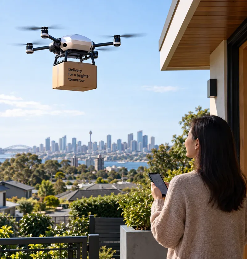
A small delivery drone approaches a residential drop-off point. Commercial scale depends on far more than the aircraft itself: inventory must be close enough, the address must be serviceable, airspace access must be legal, and the network needs a reliable handoff and fallback plan.
What does a “low-altitude delivery network” actually include?
It is easy to imagine a drone network as a set of invisible sky lanes. That is only one piece. The Federal Aviation Administration describes UAS Traffic Management, or UTM, as a collaborative ecosystem for low-altitude operations that can support flight planning, authorization, surveillance, and conflict management, particularly for beyond-visual-line-of-sight operations. The FAA also stresses that UTM is separate from but complementary to traditional air traffic services. See the FAA's current UAS Traffic Management overview.
A commercial delivery network typically needs at least these layers:
Fulfillment nodes: stores, micro-fulfillment centers, warehouses, pharmacies, restaurants, or logistics depots close enough to the customer.
Aircraft and payload system: the drone, cargo enclosure, lowering mechanism or landing method, sensors, communications, and batteries.
Airspace services: authorization, geofencing or geo-awareness, identification, traffic awareness, conflict management, and in some cases weather and conformance monitoring.
Commerce integration: inventory eligibility, checkout, customer notification, order routing, substitutions, refunds, and delivery confirmation.
Customer handoff: a safe delivery zone, package lowering or landing, clear instructions, and an alternative when the address cannot be served.
What to do: map all seven layers before comparing aircraft. If the retailer has no nearby inventory, no approved route, or no reliable drop zone, a faster drone does not solve the system bottleneck.
Misconception: “There is already one global low-altitude air-traffic network”
Verified: there are mature concepts and regional frameworks, but not one globally uniform operational network. ICAO publishes UTM guidance intended to help states build interoperable systems while protecting existing aviation. The FAA is still refining its UTM operating concept and data-exchange framework. The European Union uses a different regulatory construct called U-space. See ICAO's UTM guidance, the FAA UTM page linked above, and EASA's U-space framework.
Context-dependent: an operator may need UTM/U-space services in one area and a different approval model in another. In the EU, designated U-space airspace requires operators to use mandatory services including flight authorization, geo-awareness, network identification, and traffic information. In the U.S., UTM is still being built out alongside operator-specific approvals and certification pathways.
Still unknown: how quickly different national systems will converge on common interfaces for cross-border commercial drone operations.
What to do: treat each country—and sometimes each city or designated airspace—as a separate deployment case. Do not build a financial model assuming that regulatory approval or traffic-service integration in one market automatically transfers to another.
Misconception: “BVLOS is now routine everywhere”
Verified: beyond visual line of sight, or BVLOS, is essential to scalable delivery because a pilot cannot economically stand near every drone for an entire route. But the legal path is not universal. The FAA's July 2026 Part 107 overview still tells ordinary Part 107 operators to keep the drone within sight and notes that waivers can be requested for BVLOS and other advanced operations. Package delivery uses more advanced certification and operating approvals, including Part 135 air-carrier authority for current U.S. operators. See the FAA Part 107 overview and the FAA package-delivery-by-drone page.
The FAA proposed a dedicated BVLOS rule in August 2025 to normalize advanced low-altitude operations, but businesses should distinguish a proposed regulatory framework from permissions they already hold today. The FAA's package-delivery page, updated September 3, 2026, still describes certification, exemptions, waivers, operations specifications, and UTM development as parts of the current pathway.
What to do: before choosing a service area, document the exact authority the operator will fly under, what the approval permits, and whether it covers the desired hours, route density, aircraft type, operations over people, and number of simultaneous aircraft.
How much of the market is already real?
The answer is “more than a pilot, but not yet universal.” Two U.S. examples show both the progress and the need to separate current operations from expansion plans.
Wing and Walmart: a network built around store density
Wing said in June 2026 that it had completed well over one million commercial deliveries and that its Walmart partnership was expanding toward nearly 20 U.S. metropolitan markets. The companies announced a plan for a network of more than 270 Walmart drone-delivery locations by 2027, reaching more than 40 million Americans if the rollout is completed as planned. The June update named additional planned markets including Memphis, New Orleans, Philadelphia, Phoenix, San Diego, the San Francisco Bay Area, and Salt Lake City. See Wing's June 8, 2026 expansion announcement.
Verified: commercial deliveries and operating markets already exist. Conditional: the 270-plus-location figure is a future network target, not a claim that all of those locations were already operating in September 2026.
What to do: when reading operator announcements, put “operating now,” “announced,” and “target date” in separate columns. Expansion plans are useful demand signals, but they should not be counted as current capacity.
Amazon Prime Air: more SKUs, but still a filtered basket
Amazon's late-August 2026 update said Prime Air currently operated from 11 U.S. locations and planned to reach nearly 500 cities and towns by the end of 2026. Amazon also said it had delivered hundreds of thousands of packages by drone during 2026 and that eligible drone orders could include millions of products. At the same time, the current service still depends on package constraints: Amazon says nearly all eligible items are five pounds or less and must fit within the supported package size. See the official Amazon Prime Air 2026 expansion update.
Verified: drone delivery can now be integrated into a mainstream e-commerce checkout rather than requiring a separate experimental ordering system. Conditional: only eligible addresses, items, weather conditions, and active service locations can use it.
What to do: analyze the order basket before analyzing the aircraft. Group SKUs by weight, dimensions, urgency, margin, substitution risk, and local inventory availability. The addressable drone volume is the overlap of those categories—not total e-commerce volume.
Misconception: “Drone delivery replaces the delivery van”
Verified: current systems are best suited to small, time-sensitive orders rather than every parcel. Amazon's current five-pound threshold is one concrete example. Wing's Walmart service is positioned around rapid delivery of everyday essentials from nearby stores. In both models, drones are another fulfillment mode inside a broader retail network.
Context-dependent: drones can be especially compelling when the road route is indirect, congested, or slow relative to a short aerial path, or when customers value speed enough to justify a dedicated rapid-delivery layer. Dense apartment districts, addresses without safe drop zones, heavy grocery baskets, and bad weather can favor ground delivery instead.
What to do: design a hybrid dispatch engine. Let the system decide between drone, courier, van, pickup, or standard parcel based on item eligibility, destination, weather, promised delivery time, and network capacity.
Misconception: “Thirty-minute delivery is mostly about drone speed”
The aircraft can be fast, but the clock starts before takeoff. The item must already be stocked nearby, picked, packed, verified, transferred to a launch point, loaded, authorized for flight, and handed off safely. A retailer with a distant warehouse cannot compensate by buying a faster drone.
Wing's expansion works with Walmart stores because the stores already function as distributed inventory nodes. Amazon similarly presents Prime Air as one layer alongside Same-Day, one-hour, three-hour, and Amazon Now fulfillment options.
What to do: measure order-to-launch time separately from flight time. If picking and staging consume most of the promised window, invest in inventory placement and automation before optimizing cruise speed.
Why ground infrastructure may matter as much as aircraft range
China's low-altitude logistics buildout illustrates how scaling increasingly includes physical infrastructure rather than only vehicles. In May 2026, China's national standards program initiated a project for basic requirements for low-altitude logistics delivery landing points, covering classification, functions, site selection, and construction. The project lists transport authorities, logistics organizations, drone companies, and civil-aviation technical bodies among its drafting participants. See China's National Public Service Platform for Standards project on low-altitude logistics landing points.
Chinese local governments are also planning dense takeoff-and-landing infrastructure. Zhongshan's July 2026 action plan, for example, targets 100 drone takeoff and landing sites by the end of 2026 and includes urban drone delivery, intercity or cross-sea cargo routes, and medical transport scenarios. See the official Zhongshan government action-plan summary.
Verified: infrastructure planning is becoming formalized in parts of China. Conditional: a planned site or standard does not automatically equal profitable e-commerce demand.
What to do: evaluate each proposed landing point as a logistics node: expected orders per hour, catchment radius, charging throughput, staffing, access control, noise exposure, maintenance access, and fallback ground routes.
What does China show about route-based scaling?
China's State Council Information Office reported in March 2026 that JD Logistics had expanded drone operations to nine provinces and launched nearly 50 drone delivery routes nationwide, including 14 in Chongqing. The report described an example where a 13-kilometer mountain road journey of at least 25 minutes was replaced by an approximately eight-minute direct drone flight. See the State Council Information Office report on low-altitude logistics.
Verified: route-based drone logistics is already being used in terrain where road geometry creates a clear time penalty. Context-dependent: that does not prove the same economics in a flat urban grid with efficient ground couriers.
What to do: prioritize routes where geography creates a structural advantage—mountains, rivers, islands, campuses, industrial sites, or poorly connected suburban catchments—before attempting universal neighborhood coverage.
What does Europe add to the low-altitude network model?
The European Union's U-space framework shows what a service-based low-altitude traffic layer can look like. In designated U-space airspace, EASA lists four mandatory services: UAS flight authorization, geo-awareness, network identification, and traffic information. Optional services can include weather information and conformance monitoring. See EASA's current U-space service description.
This matters for e-commerce because dense delivery fleets need a way to exchange operational intent and traffic information without expecting conventional air traffic controllers to individually direct every low-altitude drone. But U-space is an enabling framework, not proof that retail drone delivery is equally mature across every European city.
What to do: if entering the EU, first determine whether the proposed service area is designated U-space, which U-space service providers are available, and what additional operational-category approvals the specific delivery mission requires.
Misconception: “Scaling means putting more drones in the air”
A fleet can grow and still deliver poor economics if launch sites are underused, orders arrive in bursts, aircraft spend too much time charging, weather causes cancellations, human intervention is frequent, or customers cannot provide usable drop zones.
A better definition of scale is productive network density: enough eligible orders, close enough to stocked nodes, with enough airspace and ground capacity to keep aircraft and staff productively utilized.
The FAA's March 2026 environmental review for Zipline in Pea Ridge, Arkansas, is a useful example of what operational scaling looks like in regulatory documents. The FAA evaluated an amendment that would increase authorized operations from 100 to 400 per day, permit holiday operations, and extend operations to 24 hours per day. Earlier approvals in the same location had increased the limit from 20 to 100 operations per day. See the FAA's environmental-review page for drone operations.
What to do: track deliveries per site per day, aircraft utilization, human interventions, canceled flights, average launch delay, successful first-attempt delivery rate, and cost per completed order. Fleet count alone is a weak scaling metric.
What remains uncertain?
Unit economics at very large scale
Operators disclose expansion targets and delivery volumes, but standardized public data on fully loaded cost per delivery is limited. Labor model, aircraft life, maintenance, batteries, insurance, regulatory overhead, real-estate cost, software, weather cancellations, and utilization all affect the answer.
Action: demand site-level operating data during procurement and run sensitivity analysis for utilization and intervention rate rather than relying on a headline per-flight estimate.
Community acceptance at high flight frequency
Noise, privacy perceptions, visual impact, wildlife, and concerns about operations over neighborhoods can become more important as a network moves from occasional flights to hundreds per day. The fact that FAA environmental review accompanies scaling requests is itself evidence that operations must be evaluated in their local context.
Action: measure noise and community response during the pilot, publish operating hours and complaint channels, and test route changes before committing to dense expansion.
Weather resilience
Some current aircraft can operate in light rain and broader temperature ranges, but no delivery network is weather-independent. Wind, precipitation, visibility, heat, icing risk, and local microclimates can reduce usable hours.
Action: calculate annual service availability using local weather history and define an automatic ground-delivery fallback so the customer promise survives a no-fly decision.
Cross-border interoperability
ICAO is working toward common UTM principles, but regulations, operator certificates, spectrum, data exchange, privacy requirements, and customs remain jurisdiction-specific.
Action: treat cross-border routes as aviation-plus-customs programs, not extensions of a domestic delivery radius.
A practical decision checklist for retailers and logistics operators
Define the customer job. Is the value emergency speed, convenience, rural access, reduced road distance, or a premium service tier?
Calculate eligible basket share. Filter orders by weight, dimensions, restricted goods, temperature control, packaging, and margin.
Map serviceable addresses. Exclude constrained airspace, unsafe drop zones, excessive obstacles, and locations outside practical range.
Verify the legal pathway. Document the actual operator certificate, waiver, authorization, U-space requirement, or equivalent local approval.
Model node density. Identify which stores or fulfillment centers have enough eligible demand within the flight radius.
Separate launch time from flight time. Measure picking, packing, staging, loading, authorization, flight, and handoff independently.
Build weather fallback. The checkout promise should automatically switch to ground delivery when aviation conditions are unavailable.
Plan battery and maintenance capacity. Peak orders can overwhelm charging or inspection capacity even when enough aircraft are available.
Measure human intervention. Include remote supervision, loading, maintenance, exception handling, and customer support in the labor model.
Track community impact. Noise, operating hours, route concentration, privacy perception, and complaint rates can determine whether a technically successful site is socially scalable.
So how are low-altitude networks changing e-commerce?
They are creating a new delivery tier between instant local courier service and conventional parcel logistics. For lightweight, urgent, locally stocked goods, aerial delivery can compress the physical last mile into a direct flight while software coordinates ordering, routing, airspace access, and customer handoff.
But the evidence in 2026 supports a more precise conclusion than “drones are replacing delivery trucks.” Commercial networks are expanding quickly in selected U.S. markets; China is building routes, landing infrastructure, and standards around a broader low-altitude logistics economy; Europe has established a service-based U-space regulatory architecture. These systems are converging toward higher-volume low-altitude operations, but they are not yet one seamless global network.
The retailers most likely to benefit are those that already have distributed inventory, high order density, a large share of lightweight urgent items, suitable delivery geography, and a regulatory partner capable of advanced operations. For everyone else, the smartest first step is not buying aircraft. It is identifying the subset of orders for which the sky produces a measurable advantage over the road.
Operational, regulatory, and company information in this article was checked on September 12, 2026. Expansion targets are identified as plans rather than completed deployments. Drone-delivery rules, service areas, payload limits, UTM/U-space services, and operator approvals can change; verify current official documentation before making investment or operating decisions.