Home
» Technology
»
How Urban Air Traffic Control Systems Will Safely Manage Sky-High Congestion
How Urban Air Traffic Control Systems Will Safely Manage Sky-High Congestion
As of September 2026, the emerging answer to urban air congestion is not a single futuristic control tower directing every drone and air taxi. The architecture taking shape is more layered. Traditional air traffic control remains essential where it already provides separation and manages controlled airspace, while digital traffic-management services are being developed to coordinate large numbers of highly automated aircraft, especially at low altitude.
That distinction matters because the traffic mix is changing. A city may eventually have crewed helicopters, conventional airplanes, delivery drones, public-safety aircraft, inspection vehicles, and electric vertical takeoff and landing aircraft sharing nearby airspace. The safety challenge is therefore not simply “more aircraft.” It is the combination of different speeds, performance envelopes, communications systems, automation levels, landing sites, priorities, and regulatory categories.
Current official frameworks point toward a gradual, hybrid evolution. The Federal Aviation Administration describes UAS Traffic Management (UTM) as a collaborative ecosystem that is separate from, but complementary to, traditional air traffic services. Europe’s U-space framework requires digital services such as flight authorization, geo-awareness, network identification, and traffic information in designated U-space airspace. NASA’s High Density Vertiplex research, updated in September 2026, is testing how aircraft automation, airspace automation, fleet management, and vertiport automation can work together around multiple closely spaced landing sites.
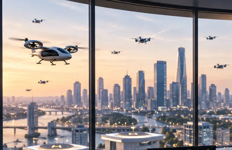
Dense urban air mobility will require coordination across aircraft, airspace services, and landing sites. The scene illustrates the kind of mixed traffic that future systems may need to manage; it is not a depiction of an operational citywide network.
The central design question: who manages which part of the traffic?
Traditional air traffic control is built around trained controllers, certified surveillance and communications systems, published procedures, and clearly assigned authority. That model is extremely strong when the number of aircraft and interactions can be handled safely by human-centered procedures. It becomes harder to extend unchanged to thousands of small, frequent, low-altitude operations because assigning a controller to tactically manage every vehicle would create substantial human workload.
Digital UTM and U-space concepts shift some coordination toward automated service providers and operators. The FAA’s UTM framework includes functions such as flight planning, authorization, surveillance, and conflict management. EASA’s U-space framework specifies four mandatory services in designated U-space airspace: flight authorization, geo-awareness, network identification, and traffic information.
Neither approach means that public aviation authorities disappear. The regulator still defines the rules, safety expectations, access conditions, and certification or acceptance processes. The practical tradeoff is between centralized human control and distributed digital coordination.
Option 1: Extend conventional ATC into urban air mobility
A conventional ATC-centered model offers familiar governance and well-understood operational authority. Aircraft communicate through established aviation channels, controllers sequence traffic, and separation responsibility remains concentrated in the existing system.
Where it works well
Early operations with low traffic volume.
Flights entering or leaving controlled airport airspace.
Operations using existing IFR or VFR procedures.
Situations where aircraft performance is similar enough for existing procedures to work without major redesign.
The tradeoff
The weakness is scalability. Human controllers have finite attention and communications bandwidth. The FAA’s Urban Air Mobility Concept of Operations Version 2.0 explicitly anticipates an evolution from initial operations within existing rules toward higher-tempo operations supported by more cooperative and automated traffic management. The document is a concept, not a final policy, but it explains why a purely controller-centric approach is unlikely to be sufficient for very dense urban operations. See the FAA UAM Concept of Operations.
Best fit: Cities or operators beginning with a small number of routes, particularly around existing airports and heliports, can benefit from conventional procedures before investing in a more complex digital ecosystem.
Option 2: Federated UTM or U-space services
A federated model distributes traffic-management functions among approved service providers, operators, and public authorities. Instead of a single controller tactically clearing every movement, aircraft operators share intent and status through interoperable digital services.
The potential advantage is scale. Computers can compare thousands of planned trajectories, check airspace constraints, identify strategic conflicts, and distribute updates faster than voice coordination alone. The FAA has already begun issuing Letters of Acceptance to some service providers supporting strategic deconfliction for commercial BVLOS operations. That is an implementation step, not proof that nationwide high-density UTM has been completed.
Where it works well
Large numbers of small UAS operating below conventional traffic.
Repeated BVLOS missions such as delivery, inspection, or public-safety operations.
Airspace where operators can reliably share position, intent, and constraint data.
Networks that need automated flight authorization and preflight conflict checks.
The tradeoff
Federation creates dependencies. Service providers must exchange data consistently, clocks and positions must be synchronized, identity must be trustworthy, interfaces must be interoperable, and failures must not cascade across the network. Cybersecurity and data governance therefore become aviation-safety issues rather than ordinary IT concerns.
Best fit: High-volume drone networks should favor federated digital services when there is a mature regulatory framework, clear service-provider responsibilities, and robust interoperability testing.
Option 3: Fixed corridors and altitude layers
One of the simplest ways to reduce complexity is to constrain traffic. Aircraft can be assigned defined corridors, preferred routes, directional altitude layers, or operating windows. The logic resembles roads: predictability can reduce the number of possible conflicts.
Advantages
Lower route-planning complexity.
Easier noise and community-impact analysis.
More predictable interactions near vertiports.
Simpler integration with geofenced or protected areas.
Tradeoffs
Rigid corridors can waste airspace. If every aircraft must follow the same narrow paths, congestion may simply move from streets to the sky. Corridors can also lengthen flights, concentrate noise, and create bottlenecks at entry points. They work best when traffic patterns are stable and the network has enough alternative capacity to handle disruptions.
Best fit: Fixed corridors are useful for early deployment, sensitive urban zones, airport interfaces, or repeated routes where predictability matters more than maximum flexibility.
Option 4: Dynamic cooperative areas
A more flexible model allows operators to coordinate within defined airspace volumes using common rules and shared operational intent. The FAA has explored this concept in several advanced traffic-management programs. Its current Higher Airspace Traffic Management work uses “Cooperative Areas” where participating operators manage conflicts through information sharing while air traffic management retains oversight and authority outside the cooperative environment.
That specific HATM concept applies to higher airspace, not urban low-altitude operations, but it demonstrates a broader design pattern: public authorities can establish the boundary conditions while qualified participants perform automated cooperative deconfliction inside the defined area.
Advantages
Flexible routing rather than permanent lanes.
Potentially higher airspace utilization.
Reduced tactical workload for traditional controllers.
Better adaptation to changing demand.
Tradeoffs
The model requires strong automation, common rules, reliable digital identity, high-quality communications, and clear fallback procedures. A participant that cannot meet the required performance may need to be excluded from that cooperative area or handled through a different operating mode.
Best fit: Mature networks with high traffic density and standardized equipage may benefit from cooperative areas after simpler operating concepts have been validated.
Option 5: A layered hybrid system
For many metropolitan areas, the most realistic architecture may combine the previous options rather than select only one. Traditional ATC can continue managing controlled airspace and airport interfaces. UTM or U-space services can coordinate lower-altitude drone traffic. Corridors can simplify especially constrained routes. Cooperative digital zones can support high-density operations when aircraft and providers meet the necessary performance standards.
The U.S. Department of Transportation’s Advanced Air Mobility Comprehensive Plan 2025 reflects this incremental direction. It calls for research into automated aircraft communications, separation standards, third-party traffic-management roles, emergency prioritization, cybersecure information exchange, and new ATC decision-support tools rather than assuming one replacement system will solve every problem.
How systems will prevent collisions before they become emergencies
Safe urban traffic management will need several layers of defense. Strategic deconfliction occurs before aircraft reach a conflict: proposed trajectories are compared, and operators adjust departure time, route, altitude, or destination. Conformance monitoring then checks whether aircraft remain within their authorized plans.
Tactical conflict management operates closer to the event. Detect-and-avoid systems, onboard sensors, surveillance data, or network services may identify an unexpected aircraft or deviation and trigger a maneuver. No single layer should be assumed perfect, so systems need fallback behavior when one source fails.
NASA’s High Density Vertiplex research is especially relevant here. Its current work evaluates automated landing, merging and spacing, and automated contingency decision-making in environments with multiple interdependent vertiports. That research highlights an important point: traffic management near landing sites is not just an airspace problem. It is also a scheduling and ground-capacity problem.
Vertiports can become the traffic lights of the sky
Even if airspace is available, an aircraft cannot land if the pad is occupied, the charging position is unavailable, or another aircraft is executing a missed approach. Urban traffic management therefore needs information about vertiport capacity as well as aircraft trajectories.
There are two main approaches. A centralized scheduler can optimize arrival slots across a network of vertiports, potentially improving global efficiency but creating a strong dependency on the central service. A decentralized model lets individual vertiports manage their own queues, which can improve local autonomy but may create inefficient network-wide decisions if sites do not share enough information.
Recommendation by need: A single operator with a small network may prefer centralized scheduling. A city with many independent operators will likely need standardized data exchange so separate scheduling systems can coordinate without requiring one company to control the entire market.
Weather management: central forecast or local sensing?
Urban wind can change sharply around towers, river corridors, rooftops, and street canyons. A citywide forecast may be adequate for strategic planning but insufficient for a final approach to a rooftop vertiport.
Centralized weather services provide consistency and reduce duplicated infrastructure. Local sensors provide higher spatial resolution but increase maintenance, calibration, communications, and data-quality requirements. The strongest architecture may combine authoritative regional weather with localized observations at critical nodes.
Recommendation by need: Low-density routes over open terrain may rely more heavily on regional aviation weather. Dense urban vertiports should evaluate whether local wind and visibility measurements materially improve dispatch and landing decisions.
Human control versus automation
Automation is necessary for scale, but fully removing humans introduces different risks. Human operators are valuable when situations are novel, ambiguous, or outside the assumptions used to design automation. Humans are less effective when asked to continuously monitor huge numbers of uneventful flights and intervene only after long periods of inactivity.
The design challenge is therefore human-autonomy teaming. Systems should automate high-volume, repetitive coordination while giving people meaningful information and well-defined authority during abnormal events. NASA’s research on fleet-management interfaces and vertiport automation treats human factors as part of system design rather than an afterthought.
Recommendation by need: Early systems should keep humans closer to operational decisions while collecting evidence about automation performance. Higher levels of automation are easier to justify after failure modes, workload, alert quality, and recovery behavior have been measured under representative traffic.
How to compare urban air traffic management architectures
Approach
Strength
Main limitation
Best-suited need
Traditional ATC-centered
Clear authority and mature procedures
Human workload limits very high traffic density
Early, low-volume AAM and airport integration
Federated UTM/U-space
Digital scalability and automated coordination
Depends on interoperability, data quality, and cybersecurity
High-volume low-altitude UAS and BVLOS networks
Fixed corridors
Predictable routing and easier procedural control
Can concentrate congestion and reduce flexibility
Repeated routes and constrained urban areas
Dynamic cooperative areas
Flexible routing and potentially high utilization
Requires mature automation and shared operating rules
Advanced high-density networks
Layered hybrid
Matches different tools to different airspace problems
More complex governance and interfaces
Large metropolitan systems with mixed traffic
Metrics that matter more than the number of aircraft
A city should not judge a traffic-management system solely by how many simultaneous flights it can display on a map. Capacity is useful only when safety and service quality remain acceptable.
Conflict-management performance: How often strategic conflicts are detected and resolved before launch or before aircraft enter the affected area.
Conformance quality: Frequency and duration of route, altitude, or timing deviations.
Service latency: How quickly position, intent, restrictions, and authorization updates propagate through the network.
Resilience: Whether operations degrade safely during communications, navigation, power, or service-provider outages.
Human workload: Number and complexity of interventions required as traffic volume rises.
Vertiport throughput: Arrival delays, missed approaches, pad occupancy, and queue length.
Mixed-traffic compatibility: Ability to accommodate helicopters, emergency aircraft, and other nonparticipating users without excessive disruption.
There is no universal threshold for these measures. Acceptable performance depends on the operational category, aircraft capability, population exposure, airspace classification, and regulator-approved safety case. The useful comparison is how each architecture performs under the same representative scenarios.
Cybersecurity and data ownership are part of air traffic safety
Urban traffic management relies heavily on digital information: aircraft identity, position, flight intent, airspace restrictions, weather, vertiport status, and sometimes vehicle health. If those data are delayed, corrupted, spoofed, or unavailable, the result can affect physical flight safety.
A centralized architecture simplifies some security controls because fewer interfaces may exist, but it creates attractive single points of failure. A federated architecture can improve redundancy but increases the number of trust relationships. The tradeoff is not simply “centralized equals safer” or “distributed equals more resilient.” It depends on authentication, segmentation, redundancy, monitoring, incident response, and how safely the system degrades.
International compatibility will matter
Different regions are developing traffic-management frameworks at different speeds. Europe has a defined U-space regulatory structure; the United States is developing UTM through FAA, NASA, industry, standards bodies, and operational approvals; other countries are adopting their own combinations of rules and services.
ICAO’s UTM guidance emphasizes the need for common boundaries and harmonization so unmanned traffic systems can interact with existing air traffic management without harming safety or efficiency. That becomes increasingly important for cross-border operations, international manufacturers, and service providers that do not want to rebuild their technical stack for every city.
What should cities and operators choose?
There is no single best urban air traffic control architecture for every stage of development.
For an early pilot with a few eVTOL routes: use existing aviation procedures wherever practical, with limited digital support and clear human oversight.
For a large drone-delivery network: prioritize interoperable UTM or U-space services, automated authorization, strategic deconfliction, conformance monitoring, and robust communications.
For a constrained downtown corridor: defined routes and operating windows may provide more predictable safety and community outcomes than unconstrained free routing.
For a mature metropolitan network: plan for a layered architecture in which ATC, digital service providers, operators, and vertiports exchange authoritative information while responsibilities remain explicit.
For cities with many independent operators: avoid designs that require every participant to use one proprietary control platform unless governance, access, pricing, and resilience have been addressed.
The likely destination is coordinated automation, not a giant control room
The future urban sky will probably not be managed like today’s busiest airport scaled up thousands of times. Nor is it likely to become an unregulated swarm in which every aircraft independently decides where to go. The evidence from FAA, EASA, NASA, DOT, and ICAO points instead toward increasingly automated coordination inside a regulated aviation system.
Traditional ATC remains valuable for authority, controlled-airspace integration, and abnormal situations. UTM and U-space can take on high-volume digital coordination. Corridors can simplify difficult locations. Cooperative operating environments can provide flexibility when participants meet common performance standards. Vertiport automation can prevent ground capacity from becoming the hidden source of airborne congestion.
The right choice depends on traffic density, aircraft mix, local airspace, available infrastructure, regulatory maturity, and the consequences of failure. A safe system is therefore not the one with the most automation or the most centralized control. It is the one that assigns each task to the layer best equipped to perform it, proves that those layers interoperate, and retains safe fallback behavior when technology or communications do not work as planned.